
Uncategorized Archive
Interactive Maps
Preferred Parking
CampusTours / October 31, 2025
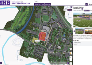
The University of Mary Hardin-Baylor AnyTour recommends several parking lots adjacent to Crusader Stadium. Ask almost any college administrator about the current hot-button issues on campus, and they
Featured

AnyTour Unveils Immersive Video Tours
CampusTours / October 12, 2024
Gemological Institute of America has recently implemented the new CampusTours ImmersiveVideoTour CampusTours is proud to announce the debut of CampusTours’ newest virtual tour product – ImmersiveVideoTours! In
Interactive Maps

Launching Video or Audio Tours from QR Codes on Building Signs
CampusTours / December 7, 2023
Colleges Embrace Technology: Launching Video or Audio Tours from QR Codes on Buildings Colleges and universities are increasingly adopting innovative technologies to enhance the student experience and attract prospective
Featured

What Students Say They Want in Virtual Tours
CampusTours / March 29, 2022
When asked by InsideHigherEd what content and features they desire in virtual campus tours, students are very clear with their top choices: Interactive Campus Map Video Tour Video
Featured
Campus Maps Deliver Online Video Orientations
CampusTours / September 21, 2021
Coupling videos with coordinated map movement is a feature CampusTours first debuted in virtual tours in 2009, but the use of “map coordinated video” has seen a dramatic rise
Featured
Inexpensive Aerial Photographs Offer Quick Campus Maps
CampusTours / September 21, 2021
As the costs of creating custom map artwork continue to rise, organizations are increasingly considering less-expensive alternatives including aerial photography. Aerial photograph maps utilize aerial photos taken from a