
Interactive Maps: Panels Versus Windows
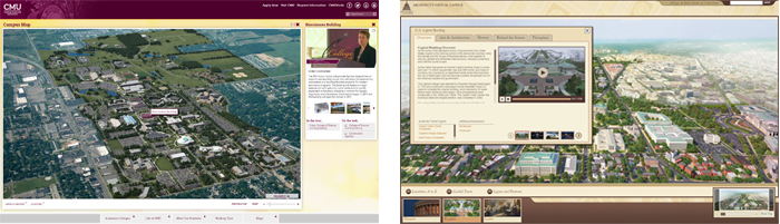
The Central Michigan University interactive map (http://tour.cmich.edu) implements building panels, while the United States Capitol interactive map (http://capitol.gov) uses building windows.
The interactive map has become a staple on most organizational Web sites, often providing visitors with their first glimpses of your location and facilities. As online maps have proliferated, a number of core features have emerged that have formed the basis for user expectations when they encounter interactive maps. These conventions include the principle that clicking on objects on the interactive map yields details or media concerning those locations, often delivered in a “window” or “panel.” The difference between delivering the information in a window versus a panel is that a window sits over top of the map, while a panel opens to the side of the map.
Windows Dominated Early Interactive Maps
Early interactive maps (1995 thru 2010) were largely dominated by designs featuring windows that popped up over the map graphic. GoogleMaps, BingMaps and MapQuest all featured windows at one point, and many organizations designed interactive maps with large windows that opened over the map and could be closed to return to the map experience. CampusTours also developed maps of this type with organizations such as the United States Capitol implementing windows on their interactive maps.
Large windows that opened over the map allowed maximum space for videos, animations, panoramic images, photographs and other content. However, almost from the outset, large windows were criticized for blocking the map itself and for limiting the “exploration value” of the map interface. When a massive window opened over the map, users were forced to close the window to return to their exploration.
Panels Offer a Solution
Initially adopted by BingMaps and GoogleMaps starting around 2006, panels have become the modern solution to the problem of presenting location content while retaining the interactivity of the map interface. Panels sit beside the map, necessitating slightly smaller media, but allowing the user the luxury of viewing both the map and the map content simultaneously. This reduces the number of clicks required for users to explore multiple map locations, because the visitor can simply click one location after another, without ever closing the panel. Retaining the map interface while presenting content to the side also allows modern interactive maps to reinforce the layout and spacing of buildings as the visitor digests content.
Panels Increase the Illustrative Value of Maps
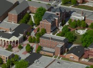
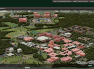
Because panels work in tandem with the interactive map, there is the opportunity for organizations to utilize content in the panels along with iconography and map movement to reinforce important spatial concepts. For instance, in a university safety video, the map can be used to highlight the location of the campus police station, and then to indicate the locations of all parking lots as these are discussed in the video. Panels also help showcase multiple locations simultaneously, by activating those locations on the map as they are discussed in a video. Panels can be configured to offer tiered content, or to bring together disparate tools like video and inquiry forms. Panels may even be stacked, allowing for nearly limitless content within map locations, while retaining map interactivity at all levels.
In most cases today, panels are the choice for organizations looking for modern interactive map design techniques. Windows are still used in some instances, but the increasing use of panels in coordination with map behavior is clearly a big reason that panels will continue to displace windows in all types of interactive maps.